Reconstructing Rome from Photographs
Aug 5, 2009 · 3 minute readA group of researchers from the University of Washington are conducting a project to construct a 3D map of Rome based on the more than 2 million results on Flickr for “Rome”. There won’t be any real results for another couple of months (so much for their “Building Rome in a Day” thing), but they’ve already got a nifty video showing their results in constructing the Colosseum. You should check it out.
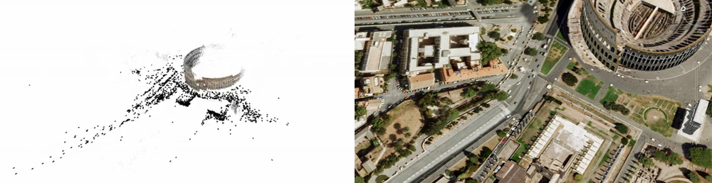
But one thing that caught my eye from their video was the idea that we can also learn about the layout of the city based on where the photographs were taken. For example, this frame from their demo video shows where all the cameras were when they snapped their shots of the Colosseum, and what direction they were pointing - that long line going down to the bottom-left corner is going down Via dei Fori Imperiali. This street is only pedestrianised on a Sunday, so we as well as placing them spatially, we can also (roughly) place these in time. I’ve put the frame next to a screenshot of the same scene from Google Earth, so you can actually see it on a map.
But look at all the whitespace - it shows exactly where people cannot or are not allowed to go. With this information, we could construct something at least as interesting, if not entirely as whizz-bang-gee-isn’t-that-nifty cool as the 3D Rome project.
So, armed with phpFlickr (to access the Flickr API), gheat (to generate the map overlay), and a couple of hours to myself, I went about constructing a heatmap showing where the most photos are taken in Rome. I did this by grabbing around 2000 photographs geotagged to within 5Km of Piazza Venezia, ranked in order of “interestingness”. There are some interesting results.
[caption align=“aligncenter” width=“500” caption=“Photo heatmap of Rome”] [/caption]
[caption align=“aligncenter” width=“500” caption=“Heatmap of Piazza Venezia / Colosseum”] [/caption]
For example, even without the map underneath, someone familiar with the layout of Rome could probably recognise this as Piazza Venezia/Colosseum area just from the shape of the “hot spots”.
[caption align=“aligncenter” width=“500” caption=“Heatmap of St. Peter’s Basilica”] [/caption]
I find this one pretty interesting because it’s a close-up image showing where people tend to take photos within St. Peter’s Basilica. They take photos right within the doorway and then above that, where the Pieta is. Then they head further in (left) and take photographs around the high altar.
I’m not sure there’s a practical application for all this, but I’m still absolutely fascinated by it - being able to see the “interestingness” of a city. From a bird’s eye level, you can see what parts of a city are most interesting (or at least visually pleasing), and then you can zoom in to a specific area or monument and see what’s most appealing in there.
Right now, I’ve only got this running on my local computer, but I’ll be trying to get this up and available online. In the meantime, I’ll be posting stuff to my Flickr account, so feel free to check it out there.